Home
›
Places
›
Sutton Benger
›
Chestnut Road
Chestnut Road
Wheelers End; 1960s
Sutton Benger
Residential
Chestnut Road used to be called 'Back Lane' but was re-named when the land to the south of the village was redeveloped for housing in the 1960s. Cowley Way, Westlake Place, Queens Close, Lee Crescent, Neville Terrace and Gregory Close became known collectively as the Chestnut Road estate. Originally, it did not join onto the High Street, but only went from Sutton Lane to near the junction with Cowley Way.
The photo is from the 1960s, when the Chestnut Road estate was being built, looking north east towards 'Starlings' and the church tower. The large white house, now No 9 Chestnut Road, used to be known as 'Wheeler's End'.
Location
Get directions from Google Maps
Media Archive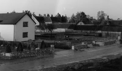
Wheelers End; 1960s