Light Up Benger Christmas Trail
Explore the 'Light Up' Benger Christmas Trail! Discover festive lights & displays at Sutton Benger residences, complete with a fun quiz for all ages. Answer questions on the app for a chance to be entered in a draw to win a book token!
This is a short family-friendly route around the heart of Sutton Benger village, pointing out places of historical interest.
This trail provides more information about places that are listed on the two 'Welcome' signs, one located on the Village Hall and one in Draycot Cerne.
The footpath sign in the far left corner of La Flambé car park leads you through the field known as Church Piece to the east-west section of Barrett Lane.
Church Piece originally comprised the two fields shown on the 1839 map as #3 and #4: described in the 1839 Survey as 'Parsonage Close' and 'Church Piece' respectively. Both these fields were given to the parish, for the benefit of the parishioners, before 1618. In that year the Churchwardens went to Court to retrieve the land from the Church, which was using the land for its own benefit. The Court ruled in the village's favour; however, it was not until fairly recently that Kay Taylor re-discovered the historical documents relating to the land. The full story is related in her book: Kay Taylor, Sutton Benger from Saxon Times to the Dawn of the 21st Century (2000).
Part One
In the medieval period it became the norm for people in England to make bequests to charity, or direct to their church, as a way of helping them to save their souls. The bequests might be a few pennies, to buy candles for the church, or might be sufficient to buy new clothes for the clergy, to build an extension to the church, or to pay for somebody to pray for their souls every day. Sutton Benger was a small community, and there were no wealthy benefactors living in the village. The bequest by William Messiter in 1607 might have been typical:
‘Item. I give and bequeath unto the cathedral church of Sarum two pence … [and] unto the church of Sutton Benger three shillings and four pence … [and] unto the poor people of Sutton aforesaid ten shillings.’
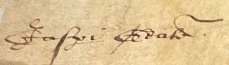
At some date, probably in the 1500s, an unknown Sutton Benger person gave an even bigger bequest: a plot of land in the village. This was donated to the parishioners – not to the church – to be used for the good of the village. But the church took control of the land, and rented it out to tenants. So a group of ordinary villagers took the tenant, Edward Somner, to court in London to regain control of the land. The parishioners included the Atkins family, who were ‘gentlemen’ and tenants of Manor Farm. But most of them were undoubtedly relatively poor and possibly illiterate farm workers. They were led by the Churchwardens, Jasper Geale (or Gale) and Richard Swayne, who ‘fronted’ the legal action on their behalf.
To all Christian people to whom this [ ? ] writing shall come. Jasper Geale, Richard Swayne, Churchwardens of the parish church of Sutton Benger in the county of Wilts send greetings ...
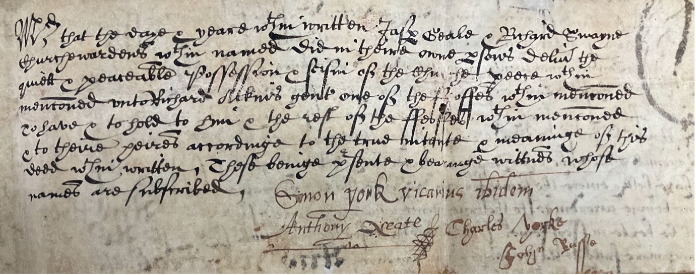
The court case started on 27 May 1617, during the reign of James I. After a year of deliberation ‘His Majesty’s Council in his honourable court of Whitehall at Westminster …’ decided in favour of the Churchwardens on 5 April 1618.
… a certain parcel of ground containing by estimation one acre or thereabouts called the Church Piece, being in the said town of Sutton Benger, heretofore given & bequeathed by some good & charitable person to the common good of the parishioners of the said parish …
… it was … ordained and decreed that the said defendant … should presently avoid … the possession of the said piece of ground called the Church Piece & yield … & deliver the quiet possession thereof unto them the said complainants …
The parishioners, together with their Vicar, Simon York, and the Churchwardens, were directed to set up a Trust to manage the Church Piece land on behalf of the villagers in perpetuity.
Part Two
The New Feoffment
At some date after 1618, Jasper Gale and Richard Swaine passed control of the Church Piece land to a new group of parishioners: John Atkyns, Gent, Richard Atkyns, Gent, Leonard Ferris, John Barnard, Ralph Gale, Walter Messiter, Richard Gale, John Coller, Richard Messiter, Thomas Box, Leonard Atkyns, and John Palmer.
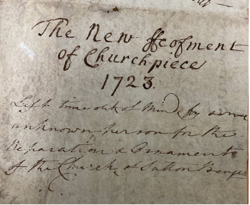
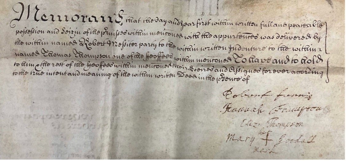
And then, in 1650, John Atkyns passed control of the land to a third group of parishioners, including John Ferris, the Vicar. (He was actually the son of the parishioner, Leonard Ferris, a previous Trustee.) But eventually, each of those Trustees died without passing control on to anybody else. So, in 1723, Robert Messiter, the grandson (or great grandson) of the Richard Messiter from 1650, was the only person with a legitimate interest in the land. He went back to the law to set up a new legal framework for ensuring that the land remained with the parishioners, as agreed by the Court in 1618. And a new group of Trustees was appointed to ensure that Church Piece was:
… to be letten forth from time to time by the Churchwardens of the said parish according to the ancient usage and employment thereof and according to the charitable disposition and good mind of the first disposer of the same and for continuance of the said piece of ground to the same uses, behoofes, intents and purposes aforesaid …
This was all written down exactly 200 years ago, in a document dated 11 February 1723 entitled The New Feoffment of Church Piece. A feoffment is an old-fashioned legal term for the grant of ownership of freehold property to somebody.
Part Three
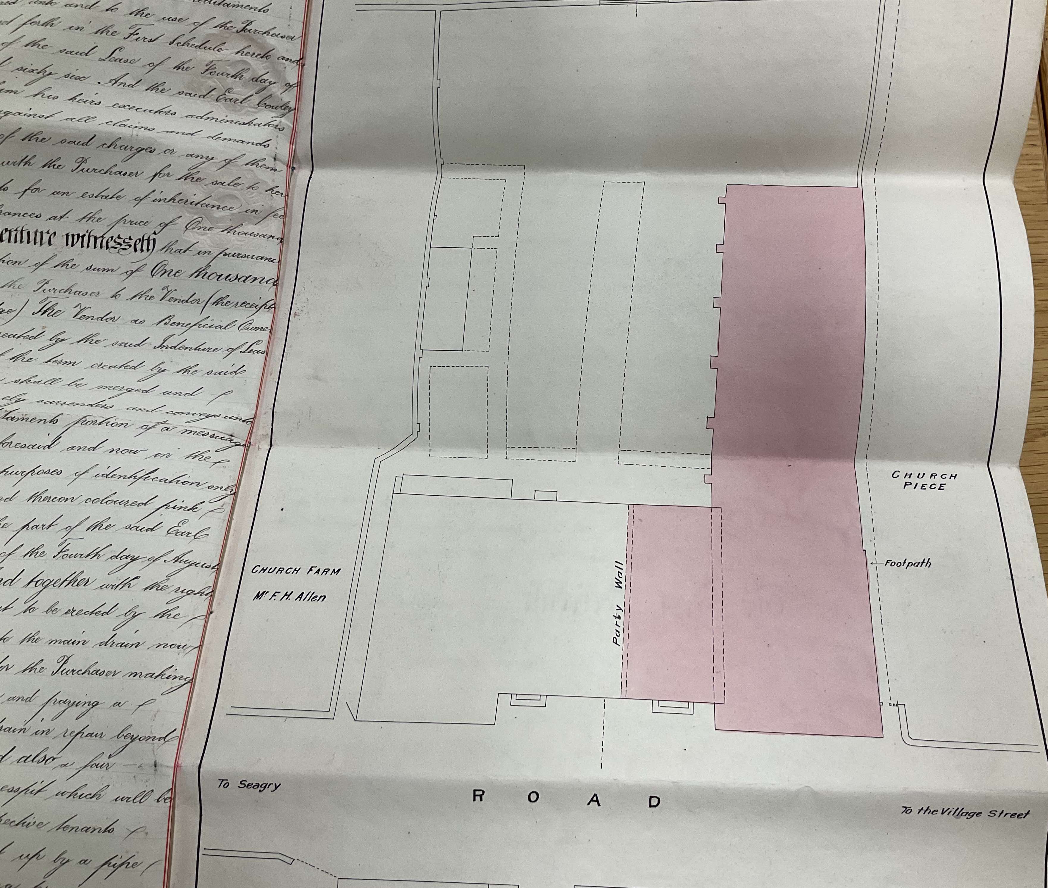
Unfortunately, after a time it appears that the Trustees forgot to appoint successors, and even the clergy forgot all about The New Feoffment of Church Piece. The fact that Church Piece belongs to the parish – and to the parishioners – became lost, until it was rediscovered in the 1980s by Kay Taylor. In her book she notes that Church Piece had actually been forgotten about again by 1869. By the early 1900s the Diocese certainly assumed that they owned all the land; they sold some of Church Piece to Wadworth’s Brewery to create a car park for The Vintage (now La Flambé); the original boundary of the land (and lack of car park) can be seen in the documents from 1926 relating to the sale of The Vintage to Wadworths Brewery.
In the 1980s The Diocese was planning to sell the rest of the land for housing. However, thanks to her re-discovery of the 1618 and 1723 documents, Kay Taylor managed to halt that final re-development, and persuaded the Diocese that the land belonged to the parish. The Church Piece charity was created in April 1993 – 375 years after the date of the original document – to ensure that the land is only used for the benefit of the village, today and for the future.
Footnote
The two Church Piece documents list various names of Sutton Benger residents. Several of them appear again and again in the history of the parish: the Atkins family, gentlemen farmers, land speculators and tenants of Manor Farm; the Coller family, and their involvement in the Civil War; the Messiter family, painters, decorators and plumbers, whose name appears on one of the Grade II Listed Monuments in the Churchyard; John Ferris, son of a yeoman farmer of the village, who became Vicar of Sutton Benger and Kington St Michael. Please get in touch if you want to hear more about any of them, or about any other person or aspect of the history of Sutton Benger parish.
If you want to help in any way, either by researching the parish history or by testing the walking / cycling routes on foot or by cycle, please get in touch at: hello@bengertrails.co.uk
The field between the church and La Flambé originally came all the way up to the building, leaving just enough space for a footpath.
The Diocese assumed that they owned all the Church Piece land, and sold some to Wadworth’s Brewery to create a car park. The original boundary of the land (and lack of car park) can be seen in the documents from 1926 relating to the sale of The Vintage.
App Settings
App Info
version 1.139